Facilities
- Home
- Research
- Research Wings
- EQRC
- Facilities
Equipment / Software
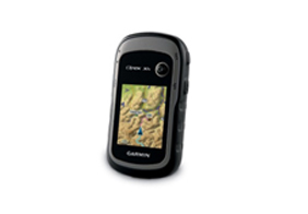
Handheld GPS
Unit: Two units
- Location survey
- Mapping while travelling
- 3-axis Electronic Compass & Barometric Altimeter Core Outdoor Navigation
- Experience Recording
QGIS 3.10 software
Unit: Two units (Open Source)
- Raster and Vector data analysis
- Geospatial analysis, Mapping
- Extend QGIS data through plugin
- WebGIS tool development

Rockwork 17 software
Unit: Single – User License
- Geological cross section and profiling
- Block model interpolation
- Multivariate mapping
- Rockware scripting (Rockware Command Language)
Voxler 4 software
Unit: Single – User License
- Create 3D model (Surface, Borehole, Contour)
- Enhance model (customization, model combination)
- Voxler Interpolation Features (Gridding, Extract, mathematical operation, transform)
- Streamlined Workflows (network manager, property manager)


Strater 5 software
Unit: Single – User License
- Borehole model
- Geological model: (Cross section and sub-surface modeling)
- Map view features (well location, boundary)
- Customized user interface features


